Designed for scientists and practitioners
Built for people who know their coast, not their solver
Many of the people who most need wave information understand their coastal environment and their management questions well, but have no training in hydrodynamic or spectral wave modelling. WEMo is built for them.
What WEMo takes care of
- Spatial setup: a grid of sites over the water at the spacing you choose.
- Bathymetry: built-in depths, or your own survey.
- Wind: decades of hourly wind over water, or a nearby buoy or station.
- Fetch and wave growth: traced in up to 56 directions over the real depths.
- Outputs: maps, exposure classes, a PDF report and GIS files, with sensible defaults throughout.
Where it is most useful
Estuaries, lagoons, lakes and other shallow or semi-enclosed coastal waters, where most of the waves are raised by the local wind. Its results support:
Accuracy appropriate to the application
More complex is not always more accurate
Accuracy and precision are different things, and the model you need depends on which one your question turns on.
Accuracy
How well the results represent the conditions you care about: which sites are exposed, which are sheltered, and by how much.
Precision
How much detail and resolution the results carry: the full wave spectrum, every process, at every point in time and space.
When the aim is to find relative exposure, tell high-energy from low-energy places, judge habitat suitability or sediment stability, compare restoration sites, or see how wave conditions change, WEMo gives estimates accurate enough for the decision. The extra precision of a full spectral wave model often would not change that decision.
The right model depends on the question being asked and the resolution it needs, not on which model is more complex.
WEMo and SWAN
Two models for different needs
WEMo is not a replacement for Delft3D-WAVE or SWAN. It occupies its own, complementary space.
WEMo
Wave exposure for environmental and coastal management decisions
- Built for
- Screening, siting, restoration and planning across whole bays, estuaries and lakes, by scientists and practitioners.
- What it needs from you
- An area drawn on a map. Depths, wind and defaults are built in; your own data can replace them.
- What you get
- Wave exposure, energy, orbital velocity and bed shear stress at thousands of sites, weighted by years of wind, in minutes.
- Precision
- A scientifically based fetch model with the main shallow-water physics, at the accuracy these decisions need.
SWAN
Detailed spectral modelling for engineering and complex wave fields
- Built for
- Engineering design, complex offshore-to-nearshore wave transformation, and studies that depend on detailed spectral characteristics.
- What it needs from you
- A computational grid, bathymetry, wind fields and boundary conditions, plus calibration, validation and specialist training.
- What you get
- The full directional wave spectrum and its evolution through generation, propagation, transformation and interaction processes.
- Precision
- Greater numerical and spectral resolution, where the site or the consequences of the decision call for it.
The difference is not simply "simple versus sophisticated" or "less accurate versus more accurate". WEMo gives the accuracy needed for many environmental, restoration, planning and screening decisions with much lower technical and training barriers. SWAN gives greater numerical and spectral precision when the complexity of the site or the consequences of the decision require it.
Results compared with SWAN
Checked against the standard spectral model, and against measurements
WEMo's defaults were tuned against SWAN at 939 sites in the lower Chesapeake Bay. They were then tested, unchanged, over the whole bay, ten times the area, with both models on identical depths and steady winds from eight directions.
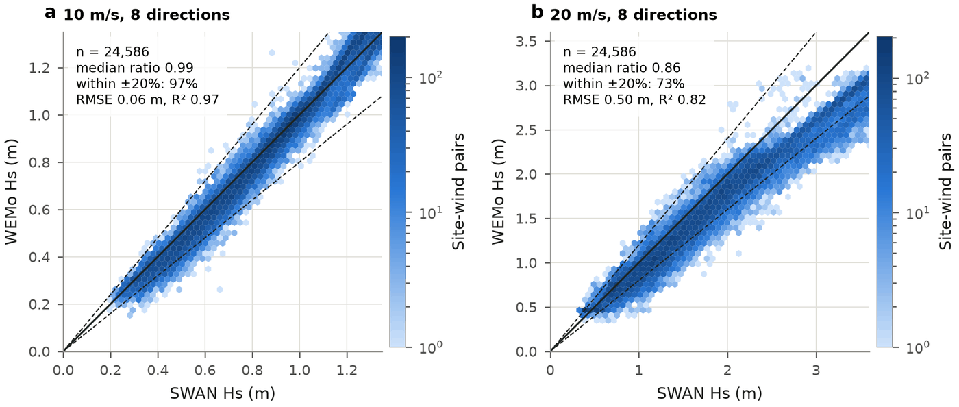
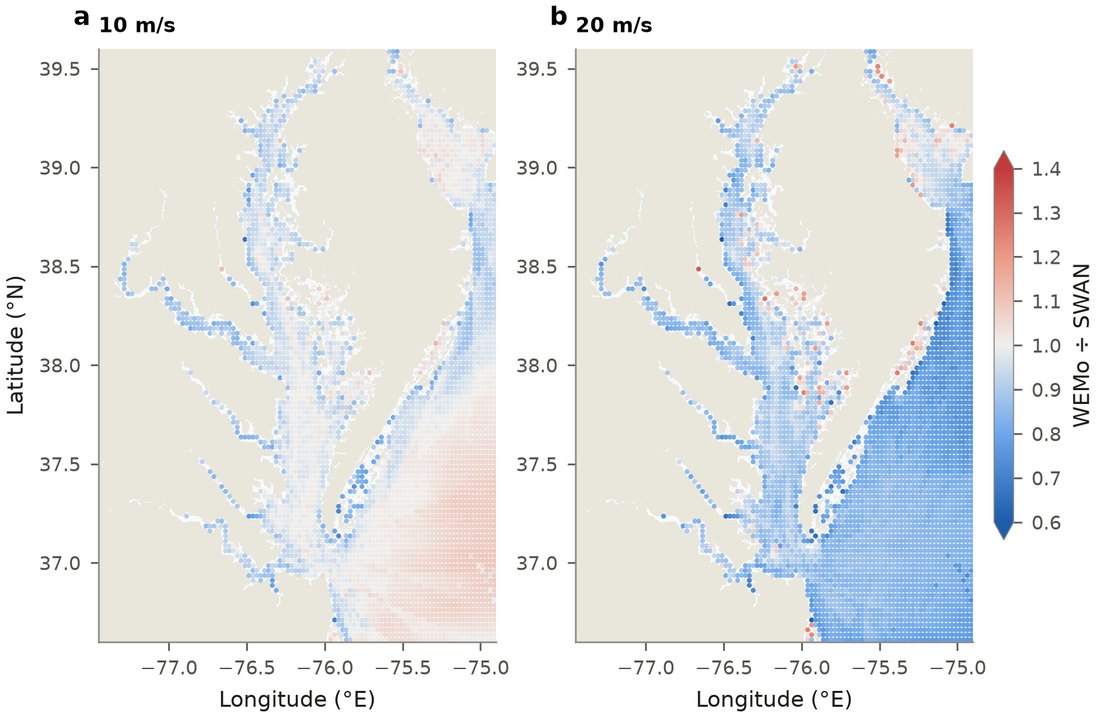
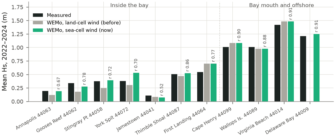
Known limits. In deep water with strong winds WEMo stays 14–20% below SWAN, yet within 6% of Kahma and Calkoen's (1992) growth curve from field measurements, which SWAN itself exceeds by about 20%. SWAN is a model, not a measurement, so a gap between the two is not automatically WEMo's error. The limitations set out where WEMo should not be relied on.
For WEMo side by side with SWAN, NOAA's original WEMo and other fetch-based tools, see how WEMo compares.
Which to use
Pick the model the question needs
WEMo fits when you need to…
- Compare wave exposure across many sites in a bay, estuary, sound or lake.
- Screen sites for seagrass, oyster reefs, wetlands, living shorelines or aquaculture.
- Judge sediment stability from orbital velocity and bed shear stress.
- Summarise years of wind into one map and report, quickly and consistently.
Use SWAN or another detailed model when you need…
- Engineering design conditions, with a coastal engineer.
- Complex offshore-to-nearshore wave transformation.
- Waves through a particular storm, hour by hour, with currents or wave setup.
- Results that depend on the detailed shape of the wave spectrum.